Catbells Walk: The Classic Circular Route from Hawse End
Sitting on the western edge of Derwentwater, Catbells is a short but punchy fell that has earned its place as a classic Lake District walk. At 451 metres, it’s often recommended as a first fell climb because, despite its relatively low height, it still delivers some of the best views in the area.
The route is easy to access, the paths are clear, and the effort-to-reward ratio is very high. You get big views quickly, a little bit of hands-on scrambling to keep things interesting, and a sense of achievement at the top. It’s ideal for families, first-timers, or anyone wanting a rewarding walk without committing to a big day.
For me, Catbells also feels very familiar. Every time I visit the Lake District with my family, we seem to end up walking it. It’s become a bit of a tradition. And even after walking it countless times, that first look back over Derwentwater never really loses its appeal, which is probably why we keep coming back to it.
In this post, I’ll give a detailed breakdown of the classic Catbells walk from Hawse End, including maps, how to reach the trailhead, and what to expect. I’ll also give some alternate route options at the end, for those who want to make Catbells a little more challenging, or who want to avoid the scramble.
Catbells walk logistics
Start/Finish: Hawse End (NY 246 212).
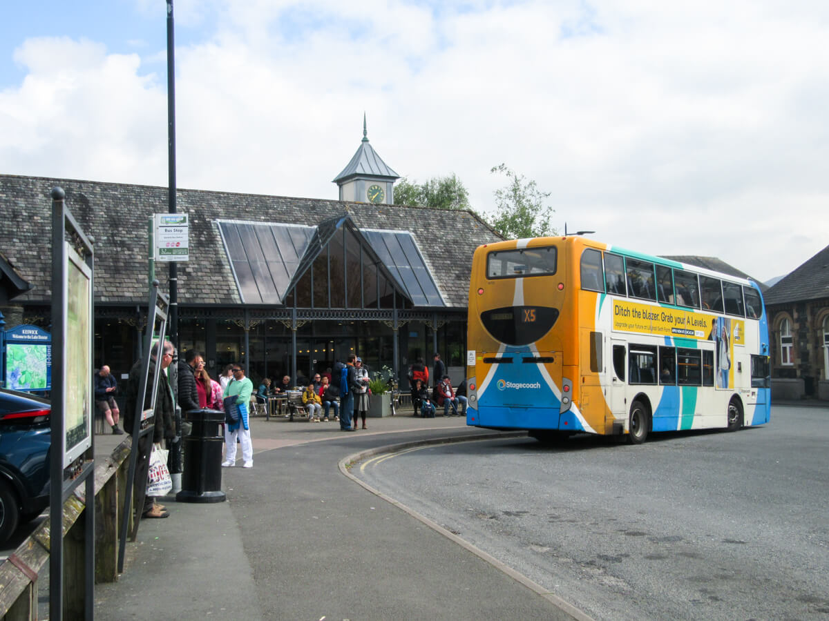
How to get there: You can use the car park at Hawse End, although spaces are limited. Alternatively, the 77A bus and the Keswick Launch (ferry) both run from Keswick to Hawse End.
Distance: 5.6 km (3.5 miles).
Time: 2 – 3 hours.
Elevation Gain: 400 metres.
Difficulty: Moderate, with some light scrambling near the summit.
Best for: Inexperienced walkers, families, people looking for a relatively short hike that still delivers great views. You’ll see people of all ages and abilities on Catbells.
Dogs: Dogs are allowed on the route, and you’ll see plenty of them.
Catbells from Hawse End map
How to get to Hawse End (Catbells trailhead)
Hawse End sits on the western shore of Derwentwater, directly opposite Keswick.
If you’re driving, there’s a free car park at Hawse End right by the start of the walk. For a lot of the year, this car park is tiny, with space for maybe 10-15 cars. You would need to get there very early to secure a spot. During the summer months, the field behind is usually opened for additional parking, and there’s a lot more space available there. Although, in busy seasons, even the field can fill up.
If the car park is full, alternative parking can be found further down towards Borrowdale, though this adds walking distance.
Because parking at Catbells can be a bit of an issue, I would really recommend taking the ferry or bus instead.
Taking the ferry (the Keswick Launch) is a really nice option. Boats run regularly between Keswick and Hawse End during the main season, and the crossing only takes a few minutes. It drops you almost directly at the start of the walk. The ferry costs £6.60 for a single ticket, and you can check the timetable here.

You can also reach Hawse End by taking bus number 77A from Keswick Bus Station (Stand 3). Services run towards Borrowdale and stop right at the trailhead. The bus costs £3 for a single ticket, and you can check the timetable here. You’ll want to get off at Hawse End Cattle Grid, and the driver usually shouts “Catbells!” at this stop so people know to get off.

If you’re staying in Keswick or Borrowdale and don’t mind adding distance, you can also walk around the edge of Derwentwater to reach Hawse End.
The Catbells Walk: Step-by-step
There are several ways to climb Catbells, but this route from Hawse End is the easiest and most popular option. Not only is it easy to follow and relatively short, but it also gives a great mix of summit views, a touch of scrambling, and a scenic return path along “The Terrace.”
Start from Hawse End
If you’re arriving by bus, you’ll see the Catbells path almost immediately after getting off. Look out for the signpost marked Catbells 1 mile.
Head away from the road on the obvious gravel path as it begins climbing through open hillside. After a few minutes, you’ll briefly cross the road, then pick the trail back up on the other side. From here, the route becomes more clearly defined as it starts heading onto the lower slopes of Catbells.
The walk gets going straight away. There’s no long flat warm-up section here. You begin gaining height almost immediately, and within minutes the views behind you start opening up across Derwentwater towards Keswick and Skiddaw.
It’s worth turning around regularly on this lower section, as the scenery builds quickly.


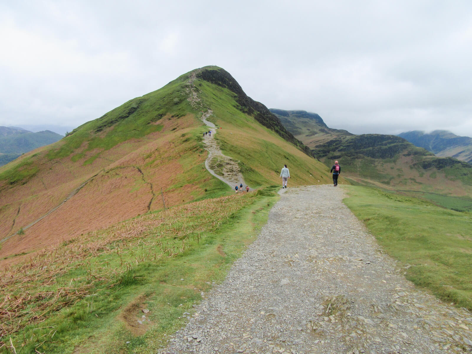
Up towards Catbells’ summit
The path now climbs steadily along Catbells’ broad northern ridge, with Derwentwater widening behind you as you gain height. This is the main ascent, and while it’s not especially long, it is fairly continuous uphill. You’ll definitely know you’re climbing.
The trail is easy to follow, with clear worn paths and occasional stone pitching. In dry weather it’s straightforward, though after rain some sections can get slippery, so I would suggest wearing decent footwear.
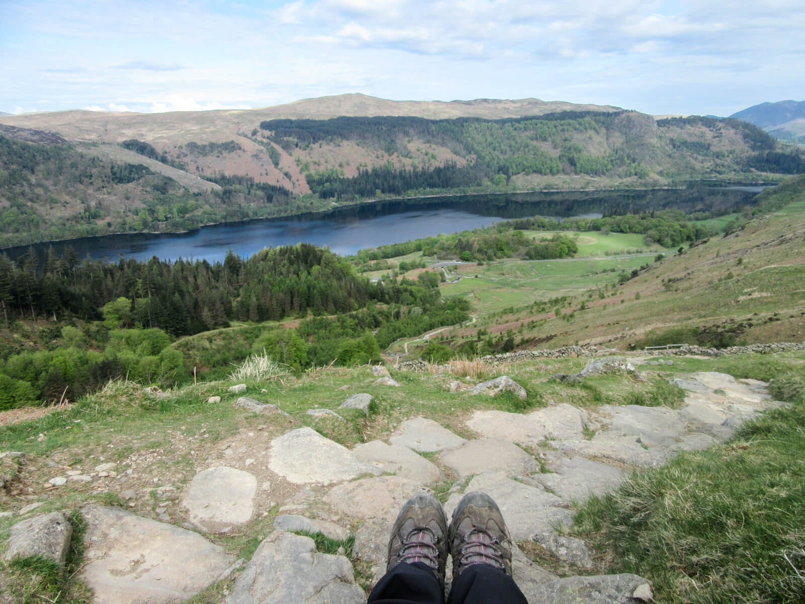
As you gain height, the views keep improving. Derwentwater spreads out below you, with the wooded shoreline, little islands, and Keswick beyond. Behind that, Skiddaw dominates the skyline.

The Catbells scramble
About two-thirds of the way up, you’ll reach a short rocky scramble just below the summit.
While it’s not a particularly technical scramble, you will need to use your hands for balance and to help yourself up a few rock steps. Most people manage it absolutely fine, including plenty of children and first-time walkers. It’s quite a fun little climb, in my opinion!
If you’re visiting during school holidays or on a sunny weekend, expect queues at the scramble.


⛰️ If you’re unsure, you can always walk up towards the summit and see the scramble, and if you decide it isn’t for you, then there’s no shame in turning back. Alternatively, there are routes that avoid the scramble entirely, which you can read about towards the end of this article.
Reaching the Catbells summit
A few final steps bring you onto the summit plateau, where you’ll find the trig point.
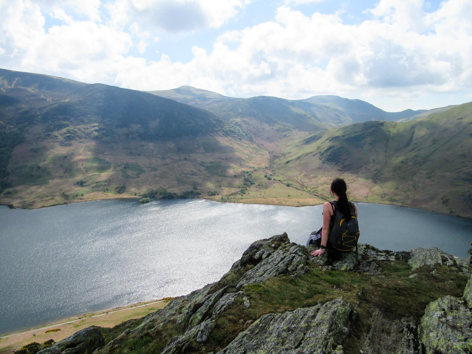
For a fell of this height, the views are exceptional. Derwentwater lies directly below, Keswick sits to the north, Borrowdale stretches south, and the Newlands Valley opens out to the west. To the south, the ridge continues towards Maiden Moor and High Spy.
On clear days, you can pick out a huge number of surrounding fells, which is one reason Catbells remains so popular despite its modest size.

Drop down via the far side of the summit
When you’re ready to continue, head directly over the summit and descend on the opposite side via the clear rocky path.
This section can feel a little awkward underfoot in places, with loose stones and uneven ground, so take your time. Before too long, you’ll reach a path junction.
Ignore the route that continues straight ahead up towards Maiden Moor. Instead, take the left-hand path going downwards. This path is quite rocky, so take your time.


Loop back to Hawse End via “the Terrace”
You’ll hit a junction after some time. Take the path going left back to Hawse End. This returning path is known as “The Terrace”, and it’s my favourite part of the walk.
Rather than dropping steeply, it contours across the side of Catbells on a relaxed path with wonderful side-on views over Derwentwater. After the busier summit ridge, it often feels quieter and more peaceful here.
The path is easy to follow as it traverses the hillside. Eventually, it rejoins the lower paths near Hawse End, where you can head back to the bus stop, ferry landing, or car park.


Why is Catbells so popular? Is it worth it?
Catbells isn’t a very well-kept secret. It’s one of the most popular hikes in the Lake District, and I think this comes down to a few reasons.
Firstly, it’s very easy to reach from the popular town of Keswick, with buses and the Derwentwater ferry stopping close to the trailhead at Hawse End. There’s also parking right by the start.
Secondly, it really punches well above its weight. For a relatively low fell, it delivers views that rival many of the higher peaks. You can get to the top of Catbells within an hour or so, and the views of Derwentwater and across Borrowdale from its summit really are fantastic.
Lastly, Catbells sits in a sweet spot in terms of difficulty. It’s not technical, but it’s not dull either. Most people will need to use their hands briefly on the small scramble near the top, which adds a bit of interest without it feeling scary. You’ll see families with young children and people well into their seventies all happily making their way up. It was actually my first ever fell walk when I was about six!
On nice days, there will be lots of people climbing it, which does sort of remove any sense of solitude. But even though it can get busy, I do think it’s still very worthwhile. It offers a lot for such a compact walk, and is an ideal introduction to fell walking in the Lake District.

How to avoid the Catbells scramble
If the rocky scramble near the summit puts you off, don’t worry, you can still reach the top of Catbells! You’ll just need to use a different route. Here are a couple of alternate routes that avoid the scramble:
1) Use The Terrace path: From Hawse End, follow the lower path known as “The Terrace,” which skirts along the bottom of Catbells. Then take the path that climbs up to the summit from the other side. Once you’ve reached the top, return the same way. This is the gentlest option, but it is quite an indirect route. See map here.
2) Start from Manesty: You can also begin from Manesty, on the Borrowdale side of Catbells. The path from here heads directly up to the summit without using the main scramble section. It’s quite a short walk at around 2.23 miles, but it is very steep. See map here.
Keep in mind: if you were to continue over the summit on either of these options, you would need to climb down the scramble, which is a lot more difficult than climbing up it. This is why both options tell you to come back down the same way you came up, thus avoiding the scramble entirely.

More Catbells walks
If you’ve already walked Catbells before, or you’re looking for a longer route, here are a couple of good alternatives worth considering:
Catbells walk & Derwentwater circular route
Best for: a longer but still relaxed half-day walk
On this route, you still climb Catbells from Hawse End, following the same well-known path to the top, but instead of looping back via The Terrace, you descend on the southern side towards Borrowdale.
The descent is gentler and less scrambly than the main ascent route, and the views change as you drop away from Derwentwater and into the valley. Borrowdale feels quieter and more expansive, with open fields, woodland, and a very different atmosphere from the busy lakeshore.
From Borrowdale, you can either walk back along Derwentwater’s shoreline or pick up paths that lead you gradually back towards Hawse End. This turns the walk into a relaxed loop rather than a straight up-and-down, adding variety without dramatically increasing the difficulty.
See the map for this route here.

Catbells to Maiden Moor and High Spy (the ridge walk)
Best for: confident hikers wanting a full day in the hills
For stronger walkers, Catbells doesn’t have to be the main event. Instead, it can be the start of a much longer day out. From the summit of Catbells, you can continue following the ridge south towards Maiden Moor and High Spy, linking several classic Newlands fells together.
The crowds thin quickly once you leave Catbells behind, and the walk becomes more open and exposed. The terrain is still straightforward fell walking, but the distance and ascent add up, turning this into a proper day hike rather than a short outing.
Views improve with height, particularly from High Spy, where you get sweeping panoramas across Borrowdale, Derwentwater, and the central Lake District fells. Descents can be made back into Borrowdale or the Newlands Valley, often finishing with a longer valley walk or a bus ride back to Keswick.
See the map for this route here.

About The Author
Lauren Pears is a freelance travel writer and blogger who writes about active adventure travel. She’s been blogging for almost 10 years, and has written for publications such as Lonely Planet, World Nomads, and Southeast Asia Backpacker.
Thank you for reading! If you found this post useful, I’d be grateful if you would consider using the affiliate links below when planning your travels. I’ll make a small commission at no extra cost to you. This will help me to keep this blog running. Thanks for your support — Lauren.
Accommodation – Booking.com
Flights – Booking.com
Travel insurance – World Nomads
Excursions & tours – Viator
Outdoor gear – Decathlon
eSIMs – Airalo
Alternatively, you could buy me a coffee to say thanks!